| The Third (Annual) Sugarbarb Farm Stolen Ride | |
|---|---|
| Saturday
Sep. 9 | Warren County is known for its hills. Come explore some new ones
with us. Walt & Claire (from whom the ride is being stolen... again)
are the
route masters; they know where the finest hills in Warren County are
hidden. Plan on about 30 miles, up and down but coming back to the same
bucolic start just the same. Barbara and Tracy want to provide the
departure location and the post-ride festivities. Sugarbarb Farm lends
itself well to the event.
We will have drinks and food; we could use some salads and deserts. And those that have a favorite beer can see that that happens. For those that wish to do more than ride and eat, we have the tennis court and of course the swimming is fairly fantastic; floats and boats are there for the using. And, farm tours. With a little effort we should be able to make a day of it, what with riding, eating, swimming, tennis, tours, and the all time-honored tradition of kicking tires and telling lies. |
| Time | 10:30 AM for preride snacks, 11:00 AM start |
| Location | Sugarbarb Farm, Blairstown, NJ |
| Distance | 22, 33, and 40 miles |
| Terrain | Mostly rolling with a couple of short hills. |
| Host | Barb and Tracy Cate |
| Contact | Barbara and Tracy Cate, 908-362-6838 (farm), 973-762-5163 (home) |
| Directions | As you are approaching the five mile mark you will be going downhill with a good view of the distant mountains. Genesis Farm has its sign on the right and farm fields on the left and right. Then there will be two single family homes on the right; we are the next farm drive. We have no box number posted, but there is a pretty neat Sugarbarb Farm sign done by the grandkids a few years ago. If you go as far as Rt. 94, you need to turn around, come back up the hill, and make the first left. As you come in the farm drive, go past the barns, past the wood fiber resource and recovery facility, stay straight at the Y, pass the tennis court, up the hill past the white house and, voila, you are at the farm house. |
| Followup | Click for after-event photos, reports, route slips, etc. |
| 11th BATS - Bike Around The Somerset Hills (non-DOGS) | |
|---|---|
| Saturday
Sep. 9 | BATS (Bicycle Around The Somerset Hills) is a one-day cycling event sponsored by the Somerset Hills YMCA, 140 Mt. Airy Rd., Basking Ridge, NJ. All proceeds support the Y's scholarship programs, which assist people who can't otherwise afford the Y's programs. BATS features rides for all skill levels from 10 to 62.5 miles. Registered riders get a T-shirt, refreshments before, during, and after the ride, and great routes to ride through the picturesque Somerset Hills. |
| Time | morning start |
| Location | Somerset Hills YMCA, 140 Mt. Airy Rd., Basking Ridge, NJ |
| Distance | 10/20/30/50/62.5 mi. |
| Terrain | Flat to hilly |
| Host | Somerset Hills YMCA |
| Contact | Donna Mallery, 908-642-4321 |
| Mercer County Loop | |
|---|---|
| Saturday
Sep. 16 | Ride around Mercer County, starting out of the West Picnic Area. We will be exploring the almost flat (the largest climb is the overpass going over Route 1) terrain around Hightstown, Princeton, and Hopewell. These roads are perfect for an excellent day out with your fellow DOGS. There is a 40 and 24 mile option over mostly flat terrain with some rolling hills. |
| Time | 9:30 AM |
| Location | Mercer County Park |
| Distance | 24 or 40 mi. |
| Terrain | Mostly flat, some rolling hills |
| Refreshments | Sandwiches and cold picnic-related food after in the park after the ride. |
| Host | Helen and Bob Bird |
| Contact | Helen and Bob, rjhbird@verizon.net, 732-382-0484 (H), 908-472-9261 (C). |
| Directions | For viewing | For printing |
| Followup | Rained out. |
| DOGS 40 and 50 mi+ Training Ride for Seagull Century (rescheduled) | |
|---|---|
| Saturday
Sep. 23 | [See DOGS 40 and 50 mi+ Training Ride for Seagull Century , Sunday, Sep. 24] |
| Time | 10:00 AM |
| Location | Red Lion Diner, 1753 Rt 206, Southampton (Vincentown) (breakfast); Brendan Byrne State Forest Park office, 1 mi south of Four Mile Circle (the intersection of Rt 70 and 72) (ride). If attending, RSVP requested. |
| DOGS 40 and 50 mi+ Training Ride for Seagull Century | |
|---|---|
| Sunday
Sep. 24 | Hope you can join us for the Seagull training ride on Saturday, September
23rd. We're really excited about this ride! Judy and I checked out
some different roads and pieced together a new ride, starting out
of Byrne State Forest (Lebanon State Forest, to many of us). We will
work on tandem pacelineing and also should get in some good socializing
- these are among the least-used roads in the state. We were on one
ten mile stretch in the park where one car passed us. Either way. Now
that's empty! The Medium is about 40 miles and the Long is probably
pushing 60. Both rides converge for the final 30 miles. Not dead flat;
there are generally small rollers to liven things up.
In order to get this sort of road, we are moving the start to the Brendan Byrne State Forest Park office, 1 mi south of Four Mile Circle (the intersection of Rt 70 and 72); it's a left at the New Lisbon sign. We are going to grab some breakfast beforehand at 8:30 AM at the Red Lion Diner, on the Red Lion Circle, Rt 70 and 206 if you can join us. Lunch is on the road in Whiting or back at the diner afterwards. |
| Time | 10:00 AM |
| Location | Red Lion Diner, 1753 Rt 206, Southampton (Vincentown) (breakfast); Brendan Byrne State Forest Park office, 1 mi south of Four Mile Circle (the intersection of Rt 70 and 72) (ride). If attending, RSVP requested. |
| Distance | 40 and 50+ mi. |
| Terrain | Flat |
| Host | Judy Allison & Malcolm Boyd |
| Contact | malcolm.boyd@intergraph.com or (856) 988-8211 |
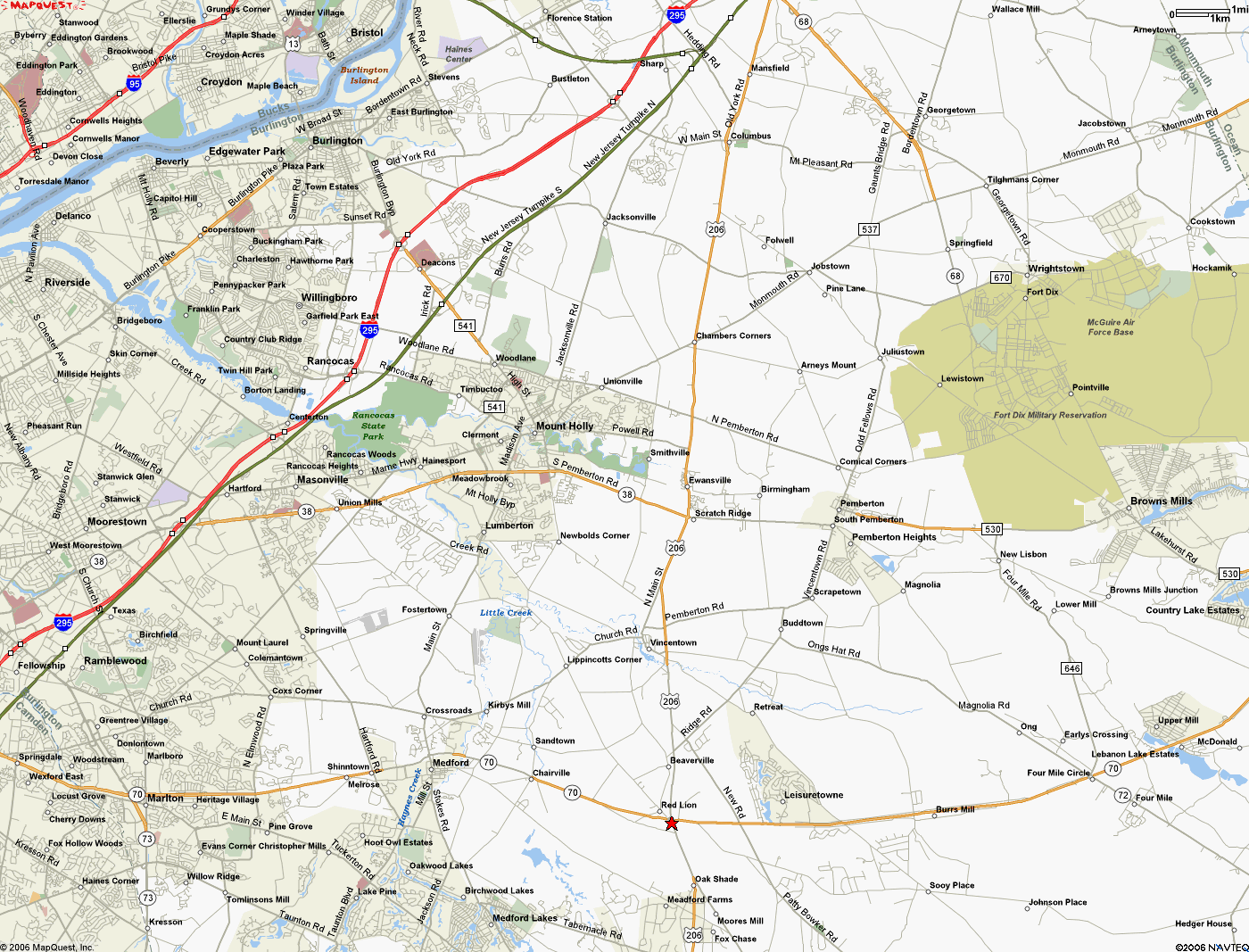
| Directions | map to diner (bottom right,
red star)
From points north:
Alternate:
Call Judy at (856) 912-0545 if you need directions. |
| RiverRide (non-DOGS) | |
|---|---|
| Friday
Sep. 29 to Sunday Oct. 1 | RiverRide, a new tour from the Bike Virginia folks, will be held on Virginia's sparsely trafficked, mostly flat Northern Neck (between the Potomac and Rappahannock Rivers.) I'd like to form a "team" (8 riders registering together) to save us each $10. If interested, please contact me by September 1 at agwiz@juno.com. |
| Location | Kilmarnock, VA |
| Terrain | flat |
| Host | Bike Virginia |
| Contact | http://www.riverride.org |
| DOGS Training Ride for Seagull Century | |
|---|---|
| Saturday
Sep. 30 | This ride is specifically to work on tandem paceline skills on our smooth and flat Burlington County roads. Training ride for the Seagull! The long route runs the Medford - Chatsworth - Green Bank - Batsto - Atsion - Medford loop. |
| Time | 10:00 AM |
| Location | Allison/Boyd house, 35 E. Centennial Drive, Medford, NJ |
| Distance | 40 and 65 mi. |
| Terrain | Flat |
| Host | Judy Allison & Malcolm Boyd |
| Contact | malcolm.boyd@intergraph.com or (856) 988-8211 RSVP if attending. |
| Followup | Click for after-event photos, reports, route slips, etc. |